


- Bertinoro
- Castrocaro Terme e Terra del Sole
- Civitella di Romagna
- Dovadola
- Forlì
- Forlimpopoli
- Galeata
- Meldola
- Modigliana
- Portico e San Benedetto
- Predappio
- Premilcuore
- Rocca San Casciano
- Santa Sofia
- Tredozio
scegli la modalità
di visualizzazione:


di visualizzazione:
Dovadola
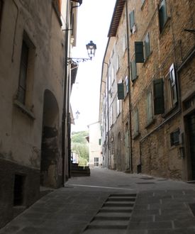 The first traces of human settlement are from the Roman times. It seems that the name of this medieval village, rising from the Montone valley to the first hills of the Tuscan-Romagna Apennines, stems from the Latin word “duo vadora”, meaning two fords. Its historical centre, as well as being dominated by the fortress erected by the Counts Guidi around the 12th century (La Roccaccia), is situated on a bend of the river which is crossed by the main road at the entrance and exit of the village.
Dovadola is surrounded by a group of houses from the same time with an amphitheatre-like central square where until 1965 the poultry market took place and thus came to be nicknamed in dialect “la piazeta dagl ovi” (eggs market square). The architecture of the village is largely influenced by the Tuscan style. The Municipality of Dovadola came to be part of Romagna only in 1923 when it was incorporated into the province of Forlì.
The hilly soil of Dovadola laid until the 60’s the basis for a farming development plan mainly in the western part of the territory with 270 farmhouses scattered all around the area, among which is the Montaguto Farmhouse, a countryhouse with oratory and manor building, located in the hamlet of San Ruffillo. First registered in 1551, the house features a memorial stone from 1882 remembering the passing of Garibaldi (1849) and the coat of arm of the Blanc Tassinaris.
The village reflects an agricultural and rural character and in the area there are also many artisan activities. Despite its proximity to Forlì, Dovadola retains its rural identity linked to its traditions, such as truffle hunting and the use of the white truffle in local cooking. Every year for 30 years Dovadola has been celebrating the prized tuber with a festival traditionally held on the third and fourth Sunday of October.
Not to be missed is also a visit to the Hermitage Montepaolo, erected close to the grotto where Saint Anthony of Padua stopped to pray in 1221, the Museum and the sarcophagus housing the remains of the venerable Benedetta Bianchi Porro preserved in the Romanesque Abbey of Sant’Andrea, which was built in the 11th century on the site of a former abbey founded by the Cluniac monks.
Altitude: 145 mslm
Inhabitants: 1.708 inhabitants
Surface: 38 kmq
How to get there
The Municipal territory of Dovadola is entirely included in the Montone valley. It borders the municipal territory of Castrocaro to the east, the municipal territory of Predappio to the south-east, the municipal territory of Rocca San casciano to the north and the territory of Modigliana to the west.
Forlì city centre is 18 km
Forlì highway exit is 25 km
Forlì railway station is 20 km
Forlì airport is 20 km
To have tourist informations
Address: Comune di Dovadola - Piazza della Vittoria 3
Telephone number: Comune +39.0543. 934764
Fax: +39.0543.934703
mail: f.gardini@comune.dovadola.fc.it
Sito WEB: http://www.comune.dovadola.fc.it
Other news
There is also the opportunity to visit agro-farming businesses and holiday farms members of the Food and Wine Route of the hills around Forlì-Cesena.
Torna indietro
da non perdere
Richiesta pubblicazioni

Comune di Forlì - Piazza Saffi, 8 47121 Forlì
PEC: comune.forli@pec.comune.forli.fc.it - P.Iva: 00606620409
A cura della Redazione di Turismo Forlivese, Piazza Saffi 8, 47121 Forlì - iat@comune.forli.fc.it - Tel. 0543 712362


