


- Bertinoro
- Castrocaro Terme e Terra del Sole
- Civitella di Romagna
- Dovadola
- Forlì
- Forlimpopoli
- Galeata
- Meldola
- Modigliana
- Portico e San Benedetto
- Predappio
- Premilcuore
- Rocca San Casciano
- Santa Sofia
- Tredozio
scegli la modalità
di visualizzazione:


di visualizzazione:
Portico di Romagna
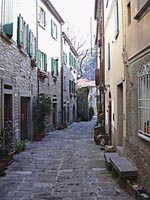 Portico was founded in ancient times along the road to Florence and
came to be known first as a market place during the Roman times and
later as a castle under the control of the Counts Guidi of
Dovadola. From 1386 the Republic of Florence chose Portico as chief
town of its Romagna territories. The village still retains its
medieval appearance and is divided into three parts: the upper part
with the castle and the parish church, the middle part facing Via
Roma with the owners' and aristocratic houses from the 13th and
14th centuries inhabited by Romagna and Tuscan noble families who
escaped here from political fights, and the lower part with the
houses of craftsmen with their workshops and of common people built
vertically (cellar, kitchen, bedroom and loft).
Portico was founded in ancient times along the road to Florence and
came to be known first as a market place during the Roman times and
later as a castle under the control of the Counts Guidi of
Dovadola. From 1386 the Republic of Florence chose Portico as chief
town of its Romagna territories. The village still retains its
medieval appearance and is divided into three parts: the upper part
with the castle and the parish church, the middle part facing Via
Roma with the owners' and aristocratic houses from the 13th and
14th centuries inhabited by Romagna and Tuscan noble families who
escaped here from political fights, and the lower part with the
houses of craftsmen with their workshops and of common people built
vertically (cellar, kitchen, bedroom and loft).
The name 'Portico' goes back to the Roman colonisation of Romagna
(inhabited at that time by the Gauls) who built here the market
gate.
The town belonged to the Holy See until 1164 when the emperor
Frederick II of Swabia enfeoffed all the town to the Counts Guidi
of Modigliana. The municipal coat of arms features an elm tree
standing in the square under which the Podesta, from 1384 every
year in the month of June, had by statute to read the laws to the
people.
What to see: Palazzo Traversari with a memorial stone dedicated to
Ambrogio dei Traversari, man of letter and prior of Camaldolite
friars, who headed the Councils of Ferrara and Florence in the 15th
century; Palazzo Portinari, from the 12th century, probably
property of Folco, the father of Dante Alighieri's beloved
Beatrice, built in Florentine style with a balcony and small
loggias leading to the tower. On the remains of the castle stands
the Portinari Tower, once known as the castle tower of the Counts
Guidi, the Clock Tower from the 15th century and the parish church,
and still in the upper part of the town is Palazzo del
Podestà with the coats of arms of the Florentine Captains.
In the lower part of the village a walk through the picturesque
Borgo Piano is worth a mention and a bit further is the Ponte della
Maestà (a humpbacked arch bridge built in the Middle Ages)
on the river Montone. The area offers a wealth of excursions to be
made, towards the Mount Busca, the Tramazzo Valley or through the
Serra Pass towards Premilcuore in the Rabbi Valley or from
Querciolano to Berleta in the Bidente valley.
Altitude: 333 mslm
How to get there
It is 38 km far from Forlì highway exit; it is 36 km far from Forlì railway station and airport.
To have tourist informations
Address: Comune di Portico - S. Benedetto - Via Marconi,
3
Telephone number: +39.0543.967047
Fax: +39.0543.967243
Sito WEB: http://www.comune.portico-e-san-benedetto.fc.it
Other news
The centre of the town is the starting point for a number of accessible trails and walks towards the ridges separating the Montone Valley from the Rabbi and Tramazzo Valleys.
Torna indietro
da non perdere
Richiesta pubblicazioni

Comune di Forlì - Piazza Saffi, 8 47121 Forlì
PEC: comune.forli@pec.comune.forli.fc.it - P.Iva: 00606620409
A cura della Redazione di Turismo Forlivese, Piazza Saffi 8, 47121 Forlì - iat@comune.forli.fc.it - Tel. 0543 712362


